Riyadh – Nucleus in the Desert
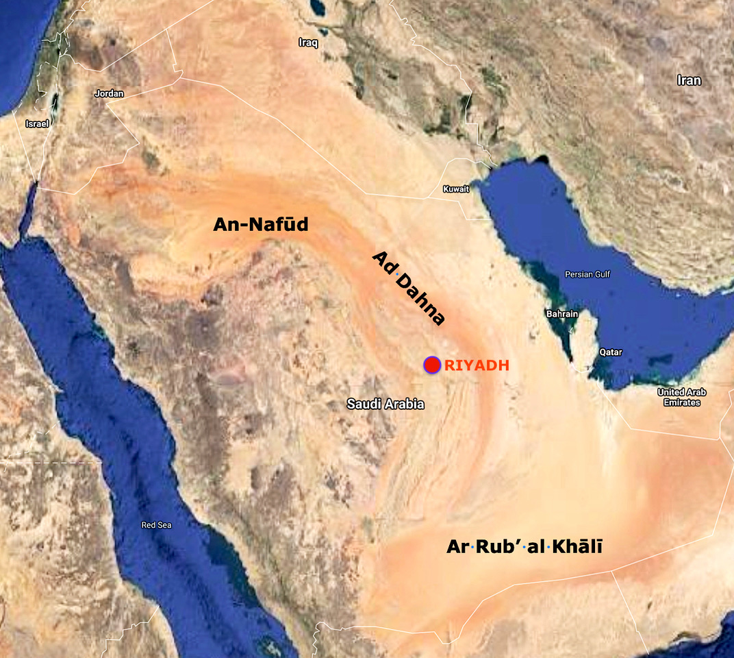
The landscape in the center of the Arabian Peninsula is largely characterised by sand and scree deserts. In the southeast of the peninsula, the largest contiguous sand desert on earth, the Rub’ al Khali (the famous, so-called Empty Quarter), extends over an area of about 700,000 km² This desert formation descends from over 800 meters near the border with Yemen to the northeast, almost to sea level near the Persian or Arabian Gulf.
The northwest is dominated by the red sand dunes of the Nafud al-Kabir (Great Desert). After the rains in winter, this region provides pasture for the Bedouins to graze their herds of cattle. The area is also of economic importance because of its phosphate deposits.
Between these two mighty desert regions, another strip, the Ad Dahna, extends in an arc about 50 km wide and more than 1,300 km long. Its plateau is an elongated, flat, barren hard-rock region of varying width in northeastern Saudi Arabia, extending to about 200-250 km northeast of Riyadh City. The region is quite flat and lies 400-450 m above sea level.
The geography of the region consists of various topographical elements extending from west to east. It includes the so-called Najd, which is a plateau with an area of about 1.1 million km². And Riyadh City is located exactly on such a plateau of 600 meters above sea level at the foothills of Ad Dahna in the eastern part of the Najd Plateau – the city is the dark-grey spot in the foto at the beginning. More specifically, the city is located in the Mintaqat Ar-Riyādh, one of the country’s 13 provinces, and where the two valleys of the Hanīfah and Al-Bathāand wadis intersect. However, the topography of Riyadh itself is relatively flat.
Rawdha – Beautiful Orchard
Riyadh (الرياض, Ar-Riyāḍh [ar.riˈjaːdˤ]) is the plural of “Rawdha,” meaning garden or beautiful orchard. The area probably received this name because it is one of the few regions in the Arabian Peninsula that offers fertile soil to its inhabitants through alluvial land. Hence, one of these scattered palm oases in the Wadi Hanīfah (Hanīfah Valley) became today’s Riyadh. The name Riyadh therefore represents the natural fertility of the region. Today, large farms are located in the Najd. Irrespective of these fertile lands, the soils in and around the city correspond to a typical steppe landscape and consist of gravel, sand, silt, clay deposits and a calcareous subsoil.
Tuwayq Mountains
The broad, mountainous plateau of Najd is surrounded in the center and in the east by steep slopes curving from north to south. The longest and highest of these is the Jabal Tuwayq, i.e., the Tuwayq Mountains, a limestone formation ranging in length from about 1,000 to 1,330 km (unfortunately, the available data vary considerably), extending from north (roughly from Buraydah) to south to the Wadi Dawasir.